Showing posts with label Dexter Industries. Show all posts

Saturday, 10 September 2011

Thermal Infrared Sensor Review (Dexter Industries Sensor)

The Thermal Infrared Sensor (TIR) is one of the latest sensor produced by Dexter Industries. It is able to measure the temperature by detecting the radiation emitting from the object. The amount of infrared radiation emitted by an object increases with temperature, thus the TIR is able to measure these emitted radiation. You should read up a little more on Thermal Imaging (Thermography) to have a better concept on how it works.

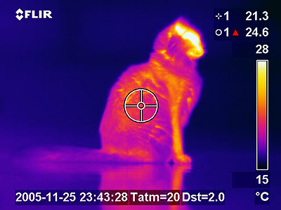
Here is a picture of a Thermal Image, captured using very expensive thermal imaging equipment, NOT our TIR sensor. However the concept is the same, it captures the emitted infrared radiation, and converts it to an image.

Here I have a simple program that takes the value from the TIR sensor and output it to the NXT display. Please note that if you are using NXT Education software, the units is in Celcius, while the NXT Retail software is in Kelvin instead.


The following is what I have tried to measure:-
  • my hand/body: 33.5°C 
    • 34°C when I measured my hands using a thermometer. Strange but I always assume that our body temp is 36.9°C
  • my router modem: 36°C
  • my laptop: 44°C (without Laptop cooler)
  • ice: 1°C    
Emissivity is a measure of a material’s radiating efficiency. Theoritically only a black body will have an emissivity of 1, thus almost everything else we measure is should be less than the actual temperature as it should have a emissivity value of less than 1. Check the emissivity list here. Please note that human skin has a value of 0.99.

There is a special block that Dexter Industries have produced to modify the emissivity value for the objects that you'll be measuring.

Here I have made a very simple software to measure the temperature of objects while the vehicle is moving. I have used the Data Logging feature available from the NXT Education's software.


The above is the measured temperature when as the vehicle is moving along for 10 seconds. Any idea what is it?

It is actually the heat produced by both my legs as the vehicle is moving in front of me. The lowest point is about 26°C (ambient) and the peak temperature is about 32°C (my legs).


I have written an equivalent for those that don't own the NXT Education's software. The above NXT-G equivalent writes the temperute to a text file as the vehicle is moving across.


Here is a simple experiment that I had devised. The first cup on the left is hot water, the centre is room temperature and the last cup is actually a frozen cup of water. 


The above is the data that I have received from the text file data, and then using excel, I have plotted the data using a colour scale. Please note that the actual measured temperature of the hot water was about 75°C (using thermometer) while the ice is 1°C (using TIR on ice directly). However when measured from the side, the temperature seems to be off by almost 10°C. I'll have to check the emissivityof these plastic cup and retry the experiment.And note that the centre cup didn't show up, because it was at room temperature!

Overall the TIR sensor is pretty good and sensitive. It is able to pick up my body temperature even when the ambient is only about 5°C different within 10" of distance.


I will be posting some of the NXT-G software up in the next few days as well as do a few more experiments.

Saturday, 27 August 2011

GPS Module Review (dGPS by Dexter Industries)


Are you bad with directions?
Do you constantly check-in on social networks like Facebook Places or FourSquare?
Do you have an Iphone, Android phone or any other smart phone?

Chances are, you would have already used, or own a GPS if you answered yes to any of the above.

So what can the GPS module bring to LEGO Mindstorms NXT that I couldn't already do on my Smartphone?

Well for starters, the GPS is actually quiet an advance piece of technology. By calcualting the distance to each satellites in space, it would be able to triangulate its current location. You should read more about the concepts and theories on how it actually calculates its location at the wiki site here.

However, this advance technology is no use if you don't understand or know how to utilise it.

The good thing about the getting the GPS module for the NXT Mindstorm is that, you'll have to write your own codes, rather than just downloading the apps and run it on the phone.

You'll need to know a little GPS concepts, and lots of creative ideas on how to implement or use it.

The review that I will be doing today would be based entirely on the NXT-G blocks that have been provided by Dexter Industries. In the photo above, I have both the dGPS module writting the to the NXT display, while on the right, I have HTC Desire with a GPS app, obtaining it the current location coordinates. If you are able to look closely, both of them are actually giving out different coordinates... of by a few decimal points.

View GPS for the LEGO Mindstorms NXT in a larger map

I have plotted both the coordinates on Google Maps. As you can see, both shows a different location, about 10 feet apart. Which one is more accurate? Well both is off by a little, as in one if off to the right, while the other is off to the left. I would need to check this with a few more location to determine which is the most accurate.

In the same map, I have also plotted a path that takes me around the KT town area. The path is marked in red. I have also attached the NXT-G files used to log the data, as well as a KML Path Creator at the end of this post.


You'll have to download 2 custom NXT-G Blocks available here. One you have downloaded and added it into your NXT-G software, you'll be to use it under the Advanced tab.

The first Block is the GPSRead, where it is able to extract all the information from your new dGPS module to your NXT. You could either write it to your NXT Display or even a text file on your NXT.

I have modified one of the sample codes to both display the information on the screen as well as write it to a file. When you write the coordinates to a file, with fixed interval, you'll be able to plot a path, as shown in the Google Map above (red path).


The next Block available is the NXTNavigation block. Given a destination coordinates, it will return the distance and angle to the destination from the current location. The usage is a little different from the GPSRead block, but it has it own purpose.

Overall the dGPS module is excellent. To log on to the satellites is pretty quick on a clear open sky (less than a minute), but takes up to a few minutes if it is very cloudy. The response that I am able to get, even at 1 second interval is acceptable.

I'll have to do more advance vehicle or robots to fully utilize the dGPS module's full potential.

Resources:
Download and view PDF Instructions on how to Collect and Upload data to Google Maps.
Download the NXT-G file for data logging here.
Download KML Path generator here.


Wednesday, 24 August 2011

dGPS Preview (Dexter Industries Sensor)

I have just received the dGPS that is made by Dexter Industries.

I have been playing over the last few days. I have been using it to collect information, that I later convert and upload directly to Google Maps

Attached here is a Google Map with me driving around the town where I stay. Used the sample codes available at Building Blocks (taken from Dexter Industries resource/downloads) and have modified it a little.

I will continue to modify the NXT-G codes, making it easier to use. Before uploading the finished NXT-G codes here.

I  am also in the middle of editing a special Excel file that will auto generate the KML file used by Google Maps. Easier to manipulate the data for upload.

I will do a full review over the next few days, completing the NXT-G codes as well as any other files created.

Stay tuned!!